


Introduction
Urban Systems, a Canadian community consulting firm, carried out a bathymetric survey project focused on stormwater infrastructure assessment. The team conducted depth mapping of storm ponds and tested their workflow in fast-flowing river segments to support sediment monitoring and volumetric analysis. The surveyed ponds varied in size, including small urban basins and mid-sized retention areas, with some sites presenting access and safety challenges due to terrain or water conditions.
Previously reliant on boat-based methods, the company faced challenges related to limited site access, extended field time, and labor-intensive data processing. In 2023, Urban Systems adopted SPH Engineering’s UAV-based echo sounder technology, thus implementing a more automated, lower-risk, and time-saving approach for both storm pond and riverine survey environments.
Challenges
Over time, several recurring issues in the boat-based workflow created inefficiencies and operational risks:
Excessive field time and redundancy. Surveyors often had to cover the same area multiple times with a boat to ensure full data coverage. This repetition led to prolonged field days, especially in ponds with irregular shapes or variable bottom profiles.
Uncertainty in data completeness. With no real-time visual confirmation during boat surveys, it was sometimes unclear whether all areas had been adequately scanned. As a result, surveyors occasionally needed to return to the site to collect missing data, increasing time and cost.
Limited access to survey sites. Steep banks, dense vegetation, or remote locations made it physically challenging to launch and retrieve boats, particularly in urban storm ponds or seasonal river inlets.
Safety risks in fast-flowing water. Surveys conducted in rivers or during periods of high water levels presented safety risks to field personnel, especially when working from boats near unstable or unpredictable flow conditions.
Risk of equipment loss. Unmanned boats required high-value positioning systems, including RTK GNSS receivers, to be mounted onboard—raising concerns about potential equipment loss in case of capsizing or mechanical failure.
Manual and time-consuming data processing. Sonar data collected from boats was exported as raw CSV files and imported into CAD software, where manual cleanup—removing spikes, correcting depth anomalies, and verifying contours—could take 15 to 20 hours per project.
Solution
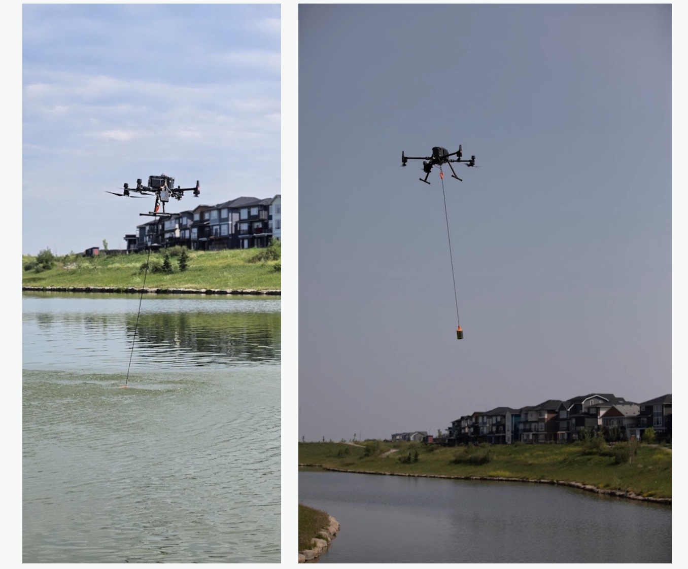
To avoid the limitations of boat-based surveys, Urban Systems deployed a UAV-mounted echo sounder system developed by SPH Engineering. The solution integrates:
- ECT D052S echo sounder;
- UgCS (Universal Ground Control Software) for mission planning and autonomous flights;
- Hydromagic software for sonar data processing and conversion to surface models;
- CAD integration for final volume and contour deliverables.
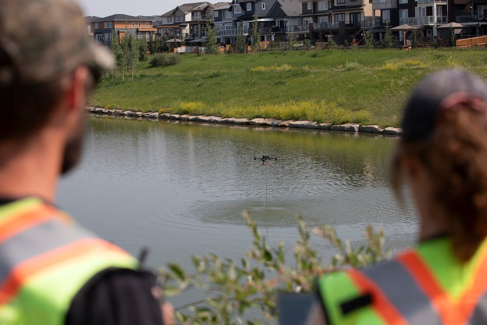
The workflow begins with UAV flight planning tailored to each site’s dimensions and geometry. Operators define flight paths to cover target areas in overlapping transects, ensuring full bottom coverage. Surveys are conducted visually within line-of-sight, typically over storm ponds or small river inlets.
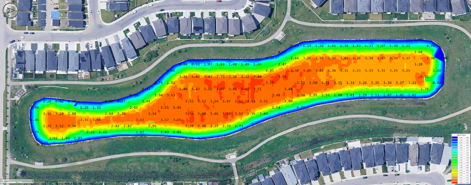
The sonar data is collected in real time and processed after the flight to generate depth models. These outputs are then aligned with existing topographic data, often derived from aerial LiDAR or previous as-built surveys, enabling the team to monitor sediment accumulation over time.
Results
Urban Systems achieved several measurable improvements after adopting UAV-mounted echo sounder technology.
Most notably, field time was reduced by approximately 75%. What once required a full day using boat-based methods could now be completed in under two hours. This allowed the team to survey multiple sites in a single day and, thus, increase throughput.
UgCS eliminated redundant data collection and reduced time spent on manual adjustments, making the survey process more predictable and easier to manage in the field.
“With the drone, we're not picking up redundant information, which is saving us field time and processing time.” — Rae Robertson, LiDAR and Drone Specialist at Urban Systems
The post-processing workload was also reduced, with data cleanup and modeling time dropping from over 20 hours to less than four hours per site. The integration with Hydromagic and real-time flight monitoring helped ensure data completeness, reducing the need for repeat visits.
Site accessibility improved as well. UAVs enabled surveys in areas previously difficult or unsafe to reach, such as ponds with steep banks or fast-flowing rivers. Data collection was conducted remotely, thus reducing the need for personnel to enter the water or navigate unstable terrain.
Additionally, by moving GNSS equipment off the water, the team reduced the risk of damage or loss to high-value gear, which had been a concern with unmanned boats in unpredictable conditions.
Finally, the quality and reliability of the collected data improved, with more consistent coverage and better alignment with existing as-built datasets.
"Now we can 99% of the time get that bathymetric survey done in a quarter of the field time." — James Mackinnon, Principal at Urban Systems
Conclusion
The integration of UAV-mounted echo sounders into Urban Systems’ workflow has transformed the way the firm conducts bathymetric surveys. Tasks that previously required significant time, manual effort, and equipment setup can now be completed more quickly using a UAV-based workflow that supports better site access, consistent coverage, and reliable data outputs.
Looking ahead, Urban Systems plans to expand the use of UAV-based surveys to larger river systems and extended cross-section mapping projects. These efforts will involve both automated flight missions and manual survey techniques depending on the site's complexity, flow conditions, and visibility requirements.