Drone-mounted Echo Sounder System for Dredging Monitoring

A UAV-based echosounding system integrates a drone platform, UgCS flight planning software, SkyHub onboard computer, single- or dual-frequency single-beam (SBES) or multibeam (MBES) echo sounder, and data processing software. It is designed for pre- and post-dredging surveys, providing bathymetric data and volume calculations in areas where vessel-based surveys are constrained by shallow water, limited access, or active dredging operations.

Workflow overview for drone-based dredging surveys

Dredging projects require reliable bathymetric data to support planning, execution, and verification of underwater excavation works. Surveys are typically performed before dredging to establish baseline depths and volumes, and after dredging to confirm achieved depths and compliance with project requirements.

Accurate bathymetric monitoring throughout the dredging lifecycle is essential for volume calculations, contractor verification, and the preparation of as-built documentation.

Typical dredging surveys

Project Condition and Pre-dredge Surveys

Both annual condition assessments and pre-dredge inspections require hydrographic surveys to evaluate the current state of the dredging area. These surveys are typically compared with as-built surveys conducted after construction projects (in the case of artificial ponds) or with the results of previous post-dredge surveys.

Post-dredge Surveys and As-Built Drawings

Post-dredge surveys are conducted usually 2 days after dredging to verify that the result has met the contract requirements and to determine if any additional work is needed.
These surveys form the basis for project acceptance and the creation of as-built drawings.

Image demonstrating ECT D24S dual-frequency echo sounder data with Eye4Software Hydromagic software

Fig.1 - Sections of Dredging Works

Our solution allows you to perform these surveys with precision comparable to boat-based methods but at a fraction of the cost and time.

Who uses the UAV-based echo sounding system

The drone-based echo sounding system is applied throughout the dredging workflow by asset owners, contractors, and survey service providers to support planning, monitoring, and verification activities.

Customers of Dredging Operations

Tasks
Plan and monitor dredging activities, and verify contractor-reported volumes.

Benefits
Achieve faster and cost-effective contractor verification compared to traditional boat-based sensor methods. UAV systems may be up to 2 times more cost-efficient than a standard approach using a ship, a boat, or an USV.

Companies Performing Dredging Operations

Tasks
Plan dredging work volumes and provide detailed customer reporting.

Benefits
Utilize precise echo sounding data for accurate work volume estimation and comprehensive reporting to clients, improving operational efficiency and transparency.

Drone Services Providers

Tasks
Incorporate pre and post-dredging monitoring surveys into service offerings.

Benefits
Leverage existing enterprise drone fleets without additional UAV purchases, enhancing service versatility of existing drone operations. The total cost for pre and post monitoring could range from $2'000 to $20'000 or more, depending on the specifics of the project.

What users say about UAV-based echo sounding system

Ariel Tarcic
Marine Survey Dept. Chief
@
Lia Engineering and Survey LTD
Israel
The use of the ERELIS airborne Hydrographic SBES system, supplied by SPH Engineering, has been a game changer in very shallow surveys. Its easy and cost-effective mobilisation made a major impact on operations costs. It gave us the ability to survey dangerous areas such as shallow breakwaters and shoreline surveys up to a minimum depth of less than 1 m. All surveys done with this technology were approved by our Cat-A Hydrographer, exceeding IHO S44 standards for SBES surveys.
Obakeng Rankhumise
Co-Founder
@
FieldServe
South Africa
Our drones, equipped with SPH Engineering's echosounder 📸 are able to make these monitoring operations a breeze. By requiring a single operator and a small takeoff and landing area, we are able to collect bathymetric information quickly and efficiently while also reducing safety risks and time spent on site. This information is then analyzed to determine the volume and location of silt deposits. By providing contractors with detailed silt maps, we help you ensure that they know exactly where to focus their efforts and how much material needs to be removed, which will allow you to plan dam maintenance projects better.
@
AltoMaxx Technologies Inc.
Canada
Our AltoMaxx pilots recently completed a GPR and Bathymetry project in Vermont, mapping the subsurface terrain above and below a stunning waterfall. 🇺🇸 🌊 Drones provide a unique advantage in water bodies like this, where deploying floating platforms or boats is impractical or difficult to control in strong currents.

Solution: UAV Echo Sounding System for Dredging Monitoring

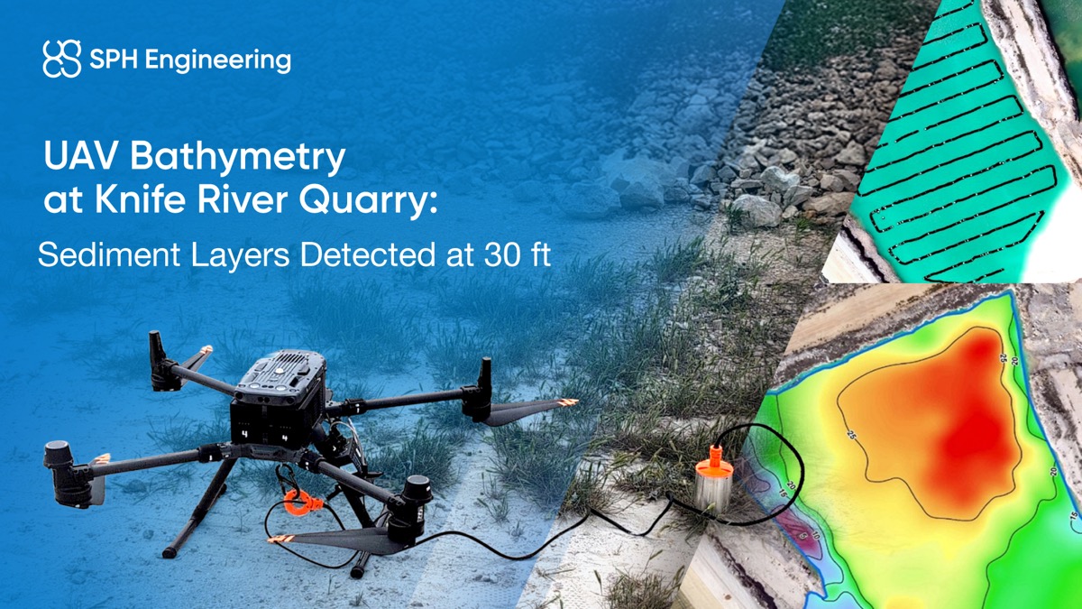
The solutions at SPH Engineering include single and dual-frequency SBES systems for effective dredging monitoring. We offer three types of SBES echo sounders and one MBES system depending on survey requirements, such as water depth, sediment conditions, and area accessibility. With sensors from EofE Ultrasonics Ltd. (SBES) or Cerulean Sonar (MBES), our UAV-borne systems deliver precise results.

How it Works

Step 1
Plan the survey with UgCS drone flight planner

UgCS is a versatile flight planner for drones. Specifically for bathymetric surveys it provides real-time telemetry and mission monitoring, delivering live data from the echo sounder. By automating surveys and efficiently covering large areas, UgCS boosts bathymetric survey productivity by at least 2 times compared to traditional methods. UgCS supports both DJI and Blue UAS drones.

Step 2
Conduct the survey with a drone

Perform the surveys with your UAV equipped with an echo sounder sensor, altimeter, and a UgCS flight plan.

Three sensors cover the majority of pre- and post-dredging surveys:
- ECT 400S single-frequency echo sounder (450 kHz)
- ECT D24S dual-frequency echo sounder (450 and 200 kHz)
- ECT D052S dual-frequency echo sounder (200 and 50 kHz)


The choice of an appropriate echo sounder depends on the conditions of your survey. Full specifications are available on our technology description page.

Alternatively, send us your conditions and requirements to discuss the best equipment for your needs.

Step 3
Download data from SkyHub

The SkyHub onboard computer is our own development of SPH Engineering company. Specifically for bathymetric surveys it registers echo sounder data and implements the proper flight mode for a drone based on data received from the altimeter.

Step 4
Process bathymetric data and calculate volumes

Bathymetric data is processed to generate depth profiles and calculate water or sediment volumes based on the difference between pre- and post-dredging surveys. The results are used for volume estimation, progress assessment, and preparation of survey deliverables.

Why is UAV a good alternative for dredging operations?

UAV-based echo sounding provides an effective alternative to the traditional methods of bathymetric surveys in projects where access, safety, or operational constraints limit the efficiency of vessel-based methods.

Hard-to-reach areas

Echo sounders on drones can access areas that are difficult or impossible to reach with traditional surveying methods, such as dense seaweed or complicated water access.

Multiple surveys of small ponds, lakes, or trenches

Drones equipped with echo sounders can efficiently conduct multiple surveys of smaller bodies of water, providing detailed and accurate data.

Cost Savings

Drones can significantly reduce the costs associated with traditional survey methods, such as using ships with the same echo sounder sensors.
This is especially true for smaller bodies of water or areas with limited access.

Accuracy

The accuracy of drone-mounted systems is the same as for manned and unmanned boats.

Enhanced Safety

Drones can remove the human element from harm’s way during initial inspections after a major failure of equipment, such as barges or cranes, reducing the risk of injury.

Case Studies

Frequently Asked Questions

When should I choose a UAV equipped with an echo sounder instead of a boat for a dredging monitoring survey?

Opt for a UAV equipped with an echo sounder in the following scenarios:
- Hard-to-reach areas near water
- Aggressive environments (e.g., alkaline or acidic conditions)
- Strong waves
- Shallow waters

Do you sell drones?

No, we focus on turnkey solutions that include hardware, advanced software, training, but we do not sell drones themselves.

Do you provide pilot services?

No. We are a technology and software development company, and drone service providers are usually among our clients.

Which drone is best suited for your system?

DJI M300/M350/M600, Inspired Flight IF1200A, Harris Aerial H6, and Wispr Ranger Pro and similar UAV.

How soon can we get this equipment shipped to the USA or Canada?

Usually delivery takes 4-6 weeks.

What is the comparison between the data's accuracy from a drone-based echo sounder and a regular boat/USV echo sounder?

The accuracy of drone-mounted systems is the same as for manned and unmanned boats because they use the same sensors.

Do you provide training?

Yes, our echo sounding system includes mandatory training on equipment usage.

What are the advantages of dual-frequency echo sounders over single-frequency ones?

Dual-frequency echo sounders offer significant advantages in environments with complex underwater features such as vegetation and sediments. They provide more reliable and detailed measurements, making them suitable for a wider range of bathymetric applications. Single-frequency echosounders, on the other hand, are ideal for shallow water surveys and simpler applications.

What depth can the echo sounder effectively measure in sedimented rivers?

Dual-frequency echo sounders, such as the ECT D052S, can effectively measure depths in sedimented rivers by using 200 kHz and 50 kHz frequencies to penetrate through organic or light sediments and reach the hard bottom. These devices can map depths up to 50-60 meters, allowing for accurate measurement in complex underwater environments.
bac2top