


Among its key features, UgCS offers a unified interface for mission planning, execution, and data analysis, whether you’re using a DJI drone or an Ardupilot/PX4-based UAV. As a comprehensive ground control software, UgCS ensures flexibility and continuity in your operations, integrating seamlessly with various flight control systems.
Here are the most common ways how Ardupilot/PX4 drones can be connected to UgCS:
- Herelink Controller
- Create an access point on the Herelink controller and connect it to the laptop running UgCS. Alternatively, both devices can be connected to a 5 GHz Wi-Fi network.
- The drone will automatically show up in UgCS.
This method is the closest one to pilots used to fly DJI drones since the Android-based Herelink controller allows the pilot to get a real-time video feed and serves as a remote controller.
- Telemetry Radio Link
- Connect the ground radio module to the laptop's USB port.
- The drone will show up in UgCS.
This method is better suited for pilots using a separate video link from the drone or not using it at all.
Both methods rely on the MAVLink protocol for communication between the drone and Ground Control Station.
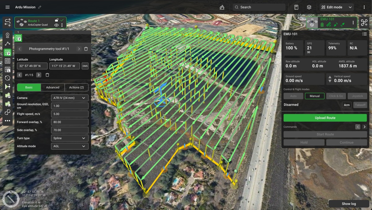
Once you have the route planned in UgCS and the drone connected, simply upload the route directly from UgCS and start it. During the flight UgCS allows to monitor the drone’s real-time location, telemetry data and send commands directly to the drone.
For Ardupilot and PX4 drones, the default open-source software available for flight planning is Mission Planner (for Ardupilot) and QGroundControl (for PX4, which also supports Ardupilot).
Comparison of the software stack of UgCS with open-source code solutions
When used with UgCS, Ardupilot and PX4 drones excel in complex missions such as mapping (photogrammetry) and LiDAR surveys. UgCS is a great alternative to Mission Planner, offering a better flight planning experience with features like 3D flight planning, DEM data import, and a user-friendly interface. These capabilities make UgCS particularly valuable for professionals needing precise and efficient mission planning.
Here are some popular Ardupilot and PX4 drone models widely used across various industries:
- Aurelia Drones: Known for their robust build and high payload capacity, ideal for industrial applications.
- Freefly Systems:
- Alta Series: Renowned for precision and flexibility, commonly used in cinematography.
- Astro: Compact and efficient, designed for professional-grade aerial imaging and mapping.
- Inspired Flight:
- IF750: Reliable and feature-rich, tailored for commercial and industrial use.
- IF1200: Heavy-lift drone for demanding applications, offering extended flight times and significant payload capacity.
- Harris Aerial: Specializes in heavy-lift drones like the H6, perfect for surveying and mapping missions.
- Watts Innovations:
- Prism: Versatile and capable of carrying various payloads, suitable for a wide range of industrial applications.
- Other Notable Models:
- Cubepilot: Versatile and customizable drone kits.
- Hex Technology: Popular Pixhawk* series, known for adaptability and performance.
We are often asked about the difference between PX4 and Pixhawk. In summary, PX4 is the open-source autopilot software, while Pixhawk refers to the hardware platform designed to run PX4. Pixhawk boards are the reference hardware for PX4, but the software can also run on other compatible flight controllers.
When paired with UgCS, these drones provide a powerful toolkit for high-precision missions, making them excellent alternatives to DJI in today’s UAV landscape.
Overall based on the experience of SPH Engineering, ArduPilot is generally a safer choice due to its larger community support and wider platform usage compared to PX4.


